Nainital
Nainital is a popular hill station in the Indian state of Uttarakhand and headquarters of Nainital district in the Kumaon foothills of the outer Himalayas. Situated at an altitude of 2,084 metres (6,837 ft) above sea level, Nainital is set in a valley containing a pear-shaped lake, approximately two miles in circumference, and surrounded by mountains, of which the highest are Naina (2,615 m (8,579 ft)) on the north, Deopatha (2,438 m (7,999 ft)) on the west, and Ayarpatha (2,278 m (7,474 ft)) on the south. From the tops of the higher peaks, “magnificent views can be obtained of the vast plain to the south, or of the mass of tangled ridges lying north, bounded by the great snowy range which forms the central axis of the Himalayas.

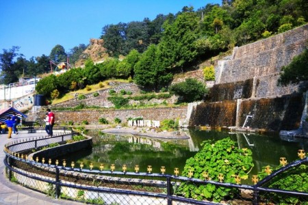
Naina Lake
Nainital Lake, a natural freshwater body, situated amidst the township of Nainital in Uttarakhand State of India, tectonic in origin, is kidney shaped or crescent shaped and has an outfall at the southeastern end. Nainital Lake, in the Nainital district called the Lake District of India, is one of the four Lakes of Kumaon hills; the other three lakes are the Sattal Lake, the Bhimtal Lake and the Naukuchiyatal Lake

Naina Devi
The Temple of Shri Naina Devi Ji is situated on a hilltop in the Bilaspur Distt. of Himachal Pradesh in India.The temple is connected with National Highway No. 21. The temple at the top of the hill can be reached via road (that curves round the hill up to a certain point) and then by concrete steps (that finally reach the top). There is also a cable car facility that moves pilgrims from the base of the hill all the way to the top.

Mall Road
Mall Road is was constructed during the British colonial rule, The Mall Road is the main road which runs through the heart of the Nainital town parellel to the lake connecting the two ends of the town. The Mall road now named Govind Ballabh Pant Marg. With the cool breeze blowing across the lake through the road an evening stroll on the Mall, has its own charm..During summers, this road is big attraction for the tourists. Nainital is flushed with choices on what to buy having exclusively the ‘Made-in-Nainital’ stamp.
Nainital Zoo
Pt. G.B. Pant High Altitude Zoo is a high altitude zoo situated in Nainital, Uttarakhand. Established in 1984 and opened to public in 1995, it is situated on the Sher Ka Danda hill at a height of 2,100 metres (6,900 ft) above sea-level and is spread over 4.6 hectares (11 acres). It is the only High Altitude Zoo in north India, besides those in Darjeeling and Sikkim. Over the years it has become a popular tourist attraction.
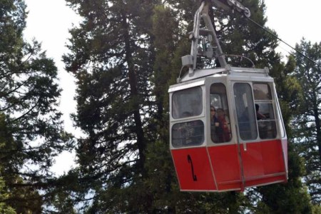
Aerial Ropeway
It is one of the main attractions of Nainital. This ropeway connects Snow-View Point (at 2270 Mts.) with Nainital near flats. Aerial ropeway starts at Mallital , there are two trolleys to carry passengers .It takes approx. 151.7 seconds to cover one way journey by trolley .Cabin capacity is 10+1 or 825 kg.
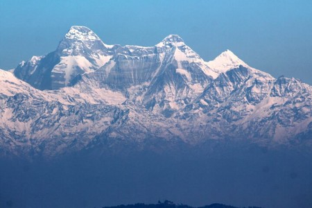
Naina Peak or China Peak
Naina peak is the highest peak of the town , at an altitude of 2611 mts. and at a distance of 6 Kms from the town .It commands an entrancing view of sparkling snow laden Himalayas from Bandar Punch in west to Api and Nari peaks of Nepal in the east , a full Himalayan range in one side and a birds eye view of the lake city of Nainital in its full grandeur on the other. With a pair of binoculars a good panorama of the tract surrounding Nainital is obtained . Pony or Horses can be hired to visit this peak either from Snow view or from Mallital.
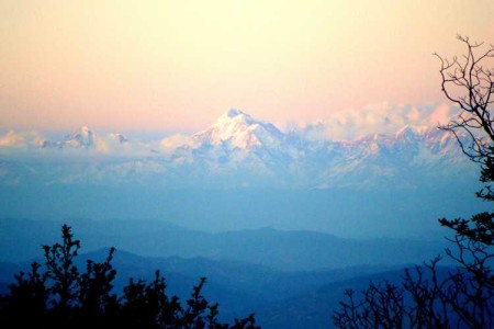
Snow View Point
Situated at an altitude of 2,270 metres, Snow View Point offers spectacular views of the snow-clad Himalayas. Located about 3 km away from the main township of Nainital, this spot can be reached by an adventurous hilly trek or a comfortable taxi drive. Out of the different ways to reach this place, the most exciting one is by cable car, which commences at Mallital.
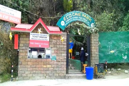
Eco Cave Garden
The Eco Cave Garden is fast becoming a popular destination. Located in Sukhtal or Mallital as it is commonly known, on the Kaladungi road, it is a natural park maintained by the local administration. A network of inter-connected rocky caves and hanging gardens, it leads the visitor into a mysterious and ancient dream – world and gives the tourist an encapsulated glimpse of what the wilderness of the hill-region can offer-right in the easily approachable middle of civilization.
Tiffin Top
TIFFIN TOP :- 7520 ft (2290 mt) in Ayarpatta region also known as Dorothy’s seat – in memory of an English lady Mrs. Kellet Dorothy, who was killed in an air crash build by her husband an admirers after her death. Tiffin Top which meanes “Packed food consumed during the day” so visitors & tourists would trek to Tiffin top with packed lunch’s and spend a quiet and peaceful picnic.
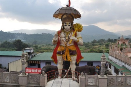
Hanuman Garhi
Hanuman Garhi, a famous Hindu temple of Lord Hanuman, is situated to the south of Tallital, approximately 3.5 km away from the Nainital bus stop. The temple is perched at an altitude of 6,401 feet from the sea level. It was built by Neem Karoli Baba, a famous local saint, around 1950. The presiding deity of Hanuman Garhi is Hanuman, a devotee of Lord Rama, who is depicted in the image as opening his chest and revealing the images of Lord Ram and Sita Mata in his heart.
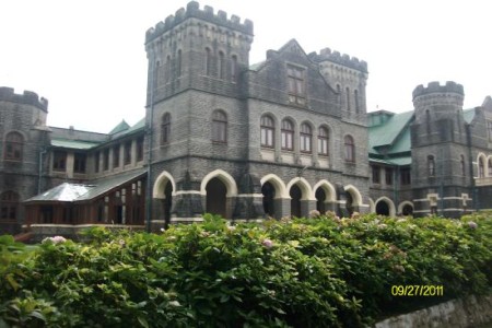
Governor House – Raj Bhawan
The Governor’s House – Raj Bhawan area is 220 acres and was built in the line of Buckingham Palace London, having double storied 113 rooms. State guests & V.I.P. coming to Nainital also use it for their stay. It consists of a marvellous Garden, Golf Links, Swimming Pool and covered with lush green area of Deodar and Oak trees. The foundation stone of the Nainital Government House, modeled after Buckingham Palace, was laid on April 27, 1897, and the building was completed in March 1900.

Land’s End
LAND’S END (2118 MT) About 4 kms from town provides a magnificent view of the plains and the beautiful Khurpa Tal surrounded by beautiful village and pine forests. The best feature of this spot is that one does not have to climb much and as the name suggests one feels on reaching the area that the end of the land has really come.